Thursday, March 30, 2017

And on to Nassau

It was hard saying good-bye to such great folks but time came to press on to our divergent journeys.  The swell had laid down from 6 feet to a mere 4 (my tongue is firmly in my cheek there.  4 foot swells are much worse than 4 foot waves.  It's like a never ending roller coaster)  Anyway, it was as good as it was going to get so we left.  We only had 17 miles to go so it wasn't going to be uncomfortable for days.  The trip was another motor boat ride so we hope we will be able to sail again someday! Nassau harbor is huge and full of ships from all over the world bringing in goods  Cruise ships are a constant as well.  It is busy enough that we have to have permission from the Harbormaster to enter and we must give our cruising permit and be logged in.  This trip is primarily to refill our water tanks and fridge and let the machines clean our clothes.  We hope to get out exploring more spots than we saw last time before we leave.  Since we're paying dock fees it won't be a long stay.  I added the street sign picture and can't make it behave so there it is.  We wondered at the story behind that name!

This little island had nothing left on it but it's coming back, at least the gazebo is.

This old light house is still in use.

There were a few of these for the cruise ships to dock.

Cruise ship row.

The mooring lines for the cruise ship are so huge.  We think that was what
we found washed up on Jaws Beach.

These concrete shapes form a breakwater for the cargo ships.

We think this is the customs house for the harbor.

Atlantis from the water side.

The famous arch you see in all the ads.  We visited the aquarium last trip
but want to see new things this time.

The bridges to Paradise Island.  Traffic is strictly controlled.  I guess
they don't want the wrong types getting on the island.

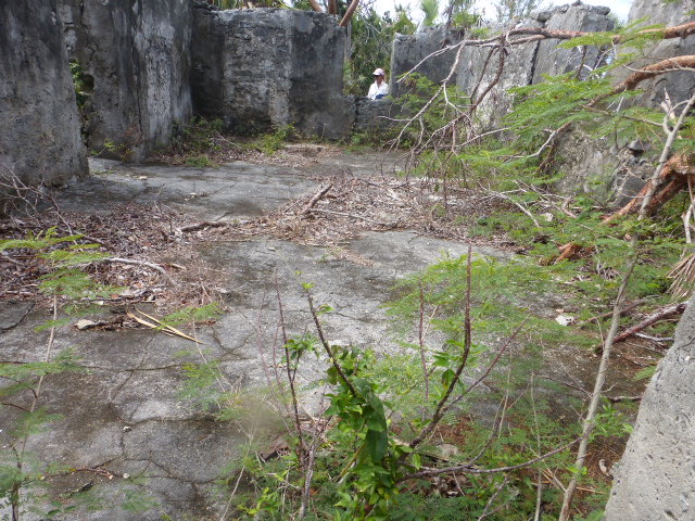
Not sure what this place was on Paradise Island but Matthew obviously
took quite a swing at hit.  Its whole seawall was washed away so there
was all the rip-rap(gray in foreground) to protect the land from further damage.

The tides are large here so my step stool is essential for me to get off
the boat onto the dock.

Not sure what this tower was.  It took a beating and didn't
appear open but it was interesting looking so I thought I'd share.

Even more Clifton

Sorry this has taken 3 posts but if I don't break them up, they take way too long to post and sometimes time out on the connection.  This place was really a neat place to visit and we spent over 5 hours there.
The park ends at the power plant.  All the signage had been washed away but our guide
map showed a set of stone steps used to bring in cargo and take out cotton bales from
the plantation. Seemed very interesting so we were determined to find them.

David heading down the stone steps.  Our efforts paid off!

From the bottom, you can see just how narrow they were.  Can you imagine bringing
a huge hogshead barrel up those?

The waves over the eons have sculpted and carved the limestone.

This huge slab of rock had come off in the recent hurricane.  I'm sure it made
quite the splash.

All those glorious shades of blue!

Walking along the fence line .

As we were walking to the next place we most have come too close to
this mama bird's nest.  She came out and acted wounded to draw us away.  If
you zoom in, you can see her colorful tail plumage.

More Clifton Park

This beach bar was  a bit of a walk from Jaws Beach but conveniently near
a parking lot.  There was also a grill setup for making everything from Lobster rolls to burgers.
The prices were high enough that our PBJ sandwiches seemed more appealing than when we packed them. 

We never saw any running carts but this one had been re-purposed to a dining facility.
It may not have been fancy, but boy what a view.

A view from the beach on our way to the headland.

The tide was going out so more beach was available to walk on.  

There were a few ruined houses on the bay side of the point.

These were on the other side of the point and there was a drawing
of what the great house looked like.  It was built in the style of a
southern plantation.  

The stone floor was still intact in this house.  I wonder what my slab
will look like in 300 years?

This is a somber and sad spot.  These are African women looking
longingly towards the place of their birth.

More ruins from the plantation era.

This is the back side of the visitor's center.  It had been made
from the plantation carriage house. It was the most intact of all the ruins.

Clifton National Park

On the other side of opulence is Jaws Beach (no sharks so not sure of the name) which is part of the Clifton National Park.  It is not a NP like you might experience in the states but it does protect some archaeological  sites from development so we were happy to support their efforts.  Jaws beach was hard hit like the rest of the area by Matthew so the restrooms are not working but there were benches to sit on and a huge dumpster for trash.  For a cruiser in the Bahamas this is a real perk.  You try not to produce a lot of trash but it happens and there are not a lot of places to store the bags so dumpsters alone are worth the price of admission. But wait, there's more! We went with our friends from the other three boats so we made quite the invasion force.
The park encompasses the entire end of that side of  the bay.  They have found evidence of an ancient Lucayan village.  These were the "Indians" that greeted Columbus.  They lived off of the products of the ocean and grew crops.  Their site was protected and not available to us.  We did see a lot of ruins from early white settlers.  To think that some of them were from the 18th century was amazing.  On the far side of the point, there was a vast plantation with the ruins of the great house and slave quarters.  We did not realize there was an admission fee since we entered the area on the beach side and walked around the end of the point and up the other side.  We were close to the entrance before we had people questioning our lack of green entry bands.  When we made it to the official entry we paid up and proudly displayed our bands.
This is the sign you see from the road.  We didn't walk on the road until
we were almost back to the beach and our dingys.

This is the symbol for the park showing the three races who have occupied this bit of land.

Not a great picture but you can get an idea of the scope of the park.

Our invasion crew.  This is Gail and Don from Island Tyme and Brenda and Mike
from Wrinkles.  Brenda broke her arm on the way to Bimini but has maintained
a really positive attitude.  Great people to meet and cruise with for at least a while. They head
for the Exumas next month while we're headed to the Abacos.

This is Jim from Amata Marie. His wife, Nancy, was taking pictures and I could
not get one of her.  They are headed for a 3 year tour of the Caribbean.

One of the unusual finds was this giant rope. David and Gail give a bit
of perspective on how huge it was.  The eye splice David is holding up
must have taken a master splicer for sure. 

Our path to adventures ahead.

We saw a few half finished structures that must be new since Matthew.
We had all packed picnic lunches so this was our stopping spot since it had
benches.

A huge wave came in to this area and washed away all the trees and brought
in a lot from the sea.  Those dots at the back of the picture were at least
200 yards up from the beach

This huge buoy was that red dot in the previous picture. That took
a tremendously powerful wave to get it up that far.

This is a cleverly disguised cell tower.  The fronds look like the took
a real beating from the storm but we were impressed that it was
even standing.

At the edge of the park boundary is the power plant for the island.  This fuel
tank must have experience a catastrophic fire.

An Amazing Place

At the end of the land surrounding the bay on the exclusive housing side, is a fantastical dwelling called Nygard Cay.  It's owner is often jetting around other places and will allow you to rent it out for only $40,000 a week.  It has it's own water park, band arena and who knows what else,  That is just what we could see from the water!

Enlarge to see some bits of wild imagination
Those look like giant golden urns.

This tower seemed to have slides coming off of it.

Wednesday, March 29, 2017

On to New Providence

Once again, an approaching storm encouraged us to move on to another protected anchorage.  This time on to West Bay on New Providence.  This is a good place to hide in mostly good sand for keeping an anchor put.  The place is surrounded by a national park on one side and the most exclusive neighbor hood in the Bahamas we've ever seen on the other side.  The houses were nothing like we have seen so far and shows there is money here.  We were pleasantly surprised to see three boats of people we had met in Boot Key then Rodriguez and Bimini.  They had left after us and skipped the Andros stop.  The weather was too rough for several days but we were able to socialize via VHF and once the weather cleared we took shore excursions and happy hours.  Cruising at it's best!
Fresh Bread was this days project

Along with fresh cookies.

This surf was hitting the reef just outside the bay.  We had only a narrow
slots to enter the bay.

Storms over, finally.

This lone tree hangs on to life on this rock at the bay's entrance.

Yep, that is just one house.

This one stretched along the water front.

This one was all along and over the bay.

This was a huge boat that came to anchor in calmer water so it could
lift the dingy up onto the deck with a crane.

On one of our walks, this was the top of the fence around the housing
area.  We walked 2 miles and never saw an entrance to the area.