Saturday, July 13, 2019

Block Island-Part 3

As you can probably guess, we both really liked Block Island.  Here are more samplings of things to love about this place.
This boat was on part of the "Magical" section of trail.  I'm afraid its
magic was all spent. A lot of the fun of hiking is that you never know
what you're going to discover around the next bend.

We swapped picture taking duties with another couple.  

One of the roads.  Note how the trees have been trimmed to
accommodate traffic.

A pavilion on the hill.

These ponds dotted the entire island. They were all on private property
as far as we could tell so I'm not sure if they were fresh or brackish.  The pond
lilies made them so beautiful.

The interior of the island is mostly dirt roads as you can see cutting
off from the main road.  We walked a lot of miles to see things since
mopeds weren't allowed on them.


This was the largest pond on the north end of the island.

Moped in action!

The island is very hilly and gave our legs and lungs a good workout.  Other
than climate, it reminded us a lot of Okinawa with the valleys and vistas.

These stiles allowed the landowners to get over their rock fences.
Tough to build a fence into rock.

Beautiful sunsets were standard.

Another ocean view from yet another hill.

Like in Okinawa, the dead have the best views!

Wild roses were everywhere.  We found them on more remote paths.
These are old fashioned climbing roses and scented the air with a splendid aroma.

Block Island- Part 2

Since we have been anchoring for free since Norfolk, we splurged and rented a moped for a few hours.  This was a fun way to see a lot of the island.  The boat is anchored far enough out the bringing the bikes to shore would have been a real chore.  The moped was fun and faster anyway.  The rest of the time we walked, covering 6-8 miles a day.
Most people say they are going to or are from Block Island but the town
does have a real name.  It is the smallest town in the smallest state in the USA.

Lines of mopeds were at all the popular tourist spots.  This was
ours.  As you can see they mostly look alike so we had to memorize
our number on the front.

The pavilion at the conservancy park on the hill.

Rock fences are everywhere!  We even saw them on remote paths
on what must have been fields at one point in history.  The amount of
effort required to gather and place the stones is mind boggling.

The bluffs as seen from the southern lighthouse.  There is a windfarm
about 3 miles offshore.

The birds in the Northeast are huge compared to what we usually see.
I suppose it's because we see them on their migration north before
they have had a chance to fatten up.

One of the trails on the island.  There are well over 25 miles of marked
trails.  I would love to see them in different stages and seasons.

This idyllic farm was at a crossroads with one trail we took.  No
mopeds or bikes allowed on the trails so the quiet was nice.  Being
a long walk from the more populated areas, we rarely saw other hikers.


The view of the cemetery from one of the trails.

The view of the same spot from the road on another walk we took.

There was a stairway to the beach at the foot of the bluffs.  We didn't have
time to make the trek down and back.

More whimsy along the way.  Someone dubbed this part of the
trail, the magical section.

Just in case you wondered where this was.

As we neared the high part of the island, the foliage thinned out.

There was a very small bit of land just off the road with large millstones
and a rock.  I suppose they didn't have anyplace else to put these artifacts
of the island's history and this was as good a spot as any other.


Block Island-Part 1

We had been told by so many people that Block Island was a "must see" destination and they weren't wrong.  This is a lovely spot not too far from any place in the Long Island or Block Islands Sounds.  From New York to Massachusetts, boaters and ferries can reach the island.  As usual, the island has had many and varied functions over the centuries.  It started off as a purchase by a group who wanted to settle and farm the rich lands.  With no natural harbor, the first owners had to swim and float all their supplies over from the ships anchored offshore.  They also had to get their livestock over the same way.  Over the years, a small harbor was built by using jetties and tourism became a major industry since the climate is generally nicer in the summer than anywhere on the adjacent mainland.  Later, a gap was opened into the Great Salt Pond from the sound on the other side of the island.  This dramatically increased boating traffic as there was now room for many boats to come visit. We spent nearly a week here and managed to see most of the island.  We were in time to go to a free Blues on the Beach concert and meet up with our Swedish friends Susan and Lars.  Sadly, we just missed a few other folks but we'll meet somewhere else I'm sure.  That is the cruising life!
Most of the Great Salt Pond is moorings owned by marinas and private
individuals.  There is a smaller area designated for anchoring.  Since it's free
to anchor, that fits our pocketbook and we can spend more ashore.

The town does provide a nice dinghy dock, also free.

This is the Old Harbor.  A much smaller spot but since most of the commercial
ferry services dock here, most of the towns shops are close to this point.  It's
about a 2 mile walk to this section from the free dinghy dock.

I loved all the houses with their varied architecture.  Most of the shingles
siding the old houses probably came from the Dismal Swamp.

One of the inns on the island.

I'm not sure if this was a private home or an inn.  I'm thinking private home
since we couldn't see any signage.

The lighthouse at the north end of the island.

An old church now private residence.  It is for sale and the ad
includes the phrase "With impressive remodel in 1980"  I don't really
see how a remodel now almost 40 years old is a selling point, no matter
how impressive it was.

We went to a hotel for cooling drinks and  this was the town
vista from the lawn.

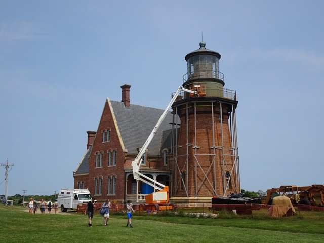
The lighthouse at the south end of the island.  A much more substantial
structure in the process of being repaired.  Views from the hill are
in a future post.

A good bit of the island is managed by the Nature Conservancy.  This park
was a the top of the hill.  We weren't sure the purpose of the turnstile as there
was not counting device attached but we found them at other conservancy trails
so it must be their thing.

As a teaching aid, they have free classes where kids pick up
debris from the beaches and make stepping stones from the junk.
This was one of the more interesting collections turned stepping stone.

Part of the stone path.

This was veteran's park with monuments to all those who fought in
wars over the centuries.

Rocks a huge part of the landscape. This was just one example of
a rock structure.

Fisher's Island

After Mass and brunch in Old Saybrook we took a leap of faith and made the short hop over to Fishers island.  We had been warned that the uber-wealthy lived there and were not welcoming.  In fact, most of the entire island is not only gated but walled.  Turned out to be a short but fun visit and we found the people quite nice.  In a lot of places we have visited in the north, you don't get a response to your "Hello" but we that was not the case on Fishers. An interesting tidbit was that Fishers is actually a New York state property.  The king granted the Duke of York ownership of the island in the early 1600s and it has remained part of New York since.  The town mooring was convenient to the dock at the yacht club and they were most welcoming.  We're glad we stopped in.
This old ship's figurehead was in the local pub we were told by one
source that we "must visit".  I think they must have been related to the
owner as a wine and a beer were $20 before tip.  People who know us
know that we don't drink premium brands so for us, that's a lot at happy hour!

Some of the hedges were eye catching.  This duck was the best of the
plant sculpting we saw.

The mooring field was full.  Considering how short the sailing season
is here, it is impressive how many folks invest in boats.

The non-gated/walled part of the island.  Like many places the
full time locals are vastly outnumbered by summer visitors for
about 3 months out of the year.

Someone has a sense of humor here.  This fireplug was just sitting out
on a rock outcropping in the middle of the harbor.

There weren't too many roads but they were clean.  No boat can
bring any trash onshore and the fine for littering is $1000.  They must
actually enforce it.

A huge difference from our  normal cruising grounds is how rocky the
bays and coves are compared to our softer, more forgiving sand.
We really have to be vigilant to not hit a shoal spot.

The island used to house a sizable Coast Guard station and we easily
recognized former base housing. This was the old movie theater and
movies were still shown by a cooperative effort.  The price is whatever
you care to donate.  If you click and look closely, you can see the iconic
 profile image of Alfred Hitchcock in ticket booth.

Wildlife of Fishers Island. 

The Yacht Club from the dock.

A lot has happened at the club since 1886, I'm sure.

The club from the road.  The building on the right was built over
100 years ago but is well maintained.  The main clubhouse is on the
left with a large meeting room.

I think this may be a popular sentiment!