Sunday, April 30, 2017

Indiantown

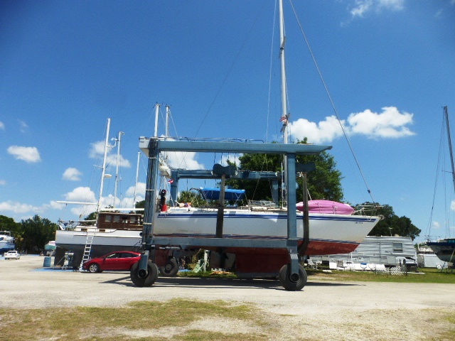
Our first night on the waterway was at Indiantown. It didn't begin so auspiciously as I hit an alligator coming into the fairway of the marina,  Judging by his reaction, he didn't like it either.  This is a great place to explore and meet other cruisers.  It is a huge boat storage yard where snowbirds and loopers leave there boat for the hurricane season and head home.  They can either have the boat shrink wrapped or just strip anything that might fly away in a storm off the boat. There is also a large area where people can work on their boat and an accompanying RV park where they can live while they work.  Some projects are so vast, years are spent in Indiantown. Some people can only devote a vacation week or  ong weekends but we met one couple who had spent 2 years getting their boat cruise ready.  As we rode around the yard, we saw many of the boats we had seen over the course of our trip there in the yard or in the marina waiting for haulout.  We shared stories and drinks with several sets of cruisers and had a lovely evening.
This other 424 caught our eye right off.  She's in rough shape but we
know how great the design is so worth the effort.

All these boats are waiting to be hauled out for the season.  This
ramp is busy all day long for weeks in the spring and then again
when the weather cools down and hurricane threats are over.

There are about 10 rows that hold over 50 boats each in this one section alone.

Some boats are still in the dreaming phase.  Sadly, there are quite a few of those in the yard.

Some people just should not be allowed to paint.

Some stands waiting on customers.

The work area is very strictly controlled for polluting debris.

One of the cruisers headed for winter quarters.

Captain Dave checking out the boats.

Our view from the v-berth.  Sure beats snow!!!

Into the Okeechobee Waterway

Only a few miles from our anchorage in Stuart, the St. Lucie Canal begins.  It is the eastern side of the complete Okeechobee Waterway connecting the coasts of Florida.  In the middle is the huge Lake Okeechobee, the second largest body of fresh water located entirely in the U.S.  Some of the Great Lakes are larger but they are partially located in Canada.    On the western side is the Caloosahatchee River and canal, ending in Fort Meyers. There is your geography lesson for the day!  For us returning from the Bahamas, this route is a short cut for us of about 500 miles.  There are two concerns for us, the bridge at Port Mayaca is only 49 feet if the lake is full.  This means we will need to lean the boat with the heeling bag but not a show stopper.  If however, the lake isn't full we can get under the bridge but there may not be enough depth to keep us floating.  This trip, the second was our concern.  There has been precious little rain so the lake is down almost 4 feet and receding daily.  We have closely watched the water level posted each day by the Corp of Engineers and read whatever reports we could find from boaters recently passing through the lake.  Our friends Ralph and Marsha are part of the Great Loop forum and gave us good intel as well.  With all our bits of information gleaned from a variety of sources we decided to risk it.  The entire waterway is so interesting.  It is unlike any other place in Florida that we have ever been. It is the only place where we've encountered the lock system and that is an experience all it's own!
Rowing is a popular sport in the quiet waters of the canals and slow
moving rivers on the east coast of Florida.

The approach to the St. Lucie Canal

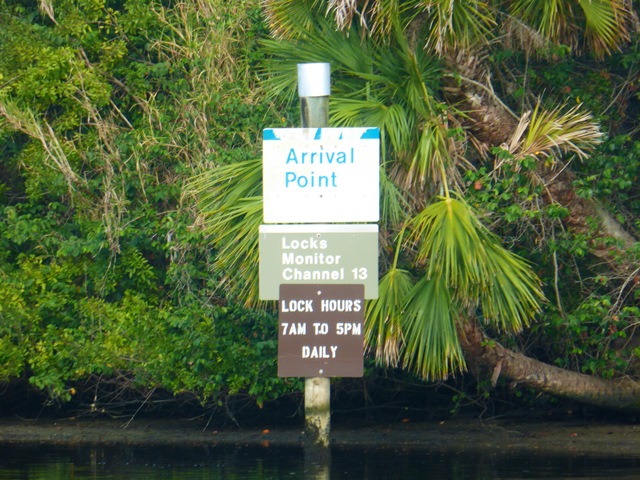
Every lock has a sign like this.  They want you to go no farther until you
are given a green light to enter the lock. This allows the oncoming boats
to clear the lock or for the doors to fully open

The St. Lucie Lock letting water out.

Each lock has a dam that stretches across the canal.

The lock seems so big until you try and maneuver in it.

In the first set of locks, we're moving up to the lake level so we
will rise about 8 feet.  There are lines hanging on the wall sides that
you grab bow and stern then hold the boat against the wall while
the water level changes.

The gates close you in.

The force of the incoming water is a sight to see.

Pumps to bring in water.


Wednesday, April 26, 2017

Stuart

We finally made our planned arrival in Stuart.  The mooring field is popular and we were lucky to snag a ball in the area reserved for boats our length.  It is not as convenient as a slip but 1/3 the price so we will take the trade off.  We have access to loaner bikes, nice shower/rest rooms and easy access to the city.  All nice things.  As everywhere, it's fun to look at other boats and talk with other folks about their trips.  We met another 424 owner from Connecticut whose boat is a few years younger than ours.  It was interesting to note the differences in the year models.  Subtle things, not like the difference in tail fins from a 56 Chevy to a 57 just different.  We took the loaner bikes around town to save having to load ours into the dingy, take them to shore then bring them back when we leave.  Stuart is a nice little town to visit.
This is the cross waterway where the St. Lucie River part of the ICW  heads
off to Lake Okeechobee from the regular North to South section.  We plan to cross the lake.
The St. Lucie Inlet.  Sadly, it's too shallow for us to enter directly
from the Bahamas.  It would cut about 40 miles off the trip.

Just before the mooring field is a set of 3 bridges.  That blue line in the
back is another draw bridge.  Lucky for us the railroad bridge didn't have a
train.  If there isn't one running, it remains open.  We have been stuck waiting
for both to open on our previous tirp.

The new bridge is nice and tall so we easily fit under.  Always interesting
to see the underside.  This is same Highway 1 that goes to Key West.


Nice sign to let you know either where your leaving or headed into.

Very nice marina if you want a place to visit!

We are way out in the south field but glad to be here.

Sunset over the marina from the porch.

Pirates in the sunset.

The marina loaner bikes.   We both kept trying to shift gears and
use the brakes on the handlebars.  Not planning to replace ours but still
nice to have available.

The shaky trees in bloom. Their real name is the Poinciana Tree.

Old Stuart is a collection of shops, restaurants and a theater.  The waterfront has a nice walkway.

This cute fellow was out enjoying the park at the same time we were.

East Coast Intracoastal Waterway

Besides our unplanned stop, there was a lot of interest along the way.  The east coast of Florida is very different from the west coast in several ways.  First, it was settled much earlier.  Henry Flagler brought his railroad and hotels down this coast bringing about popular spots for the New England rich to have a place to play in the winter.  Many of the places along the waterway are truly estates with acreage instead of the typical cheek-to-jowl development of the west coast.  Being older, the east coast is also much more crowded.  Hearing traffic of all types and seeing so many boats has been different for us.
One thing common to both coasts is lots and lots of condos.

This house had such a lush lawn stretching down to the shore.  

This is a boathouse, not the main house.  My regular house is not this big!

These must belong to one spoiled set of kids or grand-kids.
 Such cutevfloating playhouses.

This is all one house.  I couldn't get the panorama working quickly enough.

Bridge tenders like to have several boats for each opening so the line
forms on both sides.  You see the same boats all day long.

The Jupiter Inlet lighthouse.  

The chicks all lined up to head to the next bridge.

Several developments had planted rows of mangroves to control damage
from passing boat wakes.  Every so often, there would be channels to let
boat traffic in.

Osprey nests are all along the waterway.

Some sections of the ICW are basically canals with development to the
water's edge on both sides.

This intrepid explorer came up our scupper from under the boat back in
North Palm Beach and stayed with us for several days.

Once he became so used to us or so hungry that he wanted to join
us in the cockpit, we sent him back to his watery home.

Sailing North to Stuart

We left North Palm Beach with the idea of making it all the way up to the mooring field at Stuart but passed this interesting looking anchorage and looked it up on Active Captain and it sounded intriguing so we found a wide spot in the channel and turned back.  Good decision.  It was a safe anchorage along the Hobe Sound National Wildlife Refuge.  This spot is inaccessible by car so the beaches were secluded.  I'd like to say they were pristine, but any beach close to an urban area is going to show signs of trashy people leaving their junk behind or throwing it overboard to wash up on the beach. Other than that, it was a fantastic overnight sojourn.
The boundary was clearly marked with the usual dos and don'ts

The weather stations were also clearly marked "Do not disturb" Since
we rely so heavily on accurate weather, we complied.

David said this was my "money shot" the arching sea grapes made
a beautiful bower.

More sea grapes

This NWR is so critical to many endangered species including sea turtles.
Rangers mark the nests and keep a close eye on them to prevent poaching.

Sea oats are all over the dunes.  Just one of the salt tolerant plants
holding the barrier islands together.

These seed pods are wicked looking but this is the first time we've seen
them open and full of seeds.  They belong to a vine.  I called them man-eaters
because they reminded me of the man-eating plant in the Little Shop of Horrors.

Beautiful beach vine in bloom.

A trail along the middle dune system

The middle of the dune systems are full of small critter habitats.

One hairy, empty coconut shell.

Crab holes are everywhere.

You can see the tracks of so many types of birds and other animals in the sand.

Turtle patrol tracks.

Our dinghy patiently waiting for our return